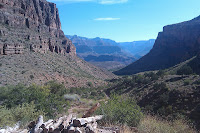
The Grand Canyon has never really held any kind of special place in my heart. I've only been to the South Rim, what everybody thinks of as "The Grand Canyon", once and that was probably 10 years ago. I've hiked some other easy trails in the canyon but never this one.
The idea struck me at some point this year to do a Rim-to-Rim-to-Rim hike in a day which is something like 40 miles. I was thinking late October and that would coincide with my Ironman training pretty well. Doug and I were throwing the idea around, but obviously he won't be making the trip.
Never having really hiked in my life I decided to do a shorter Rim-to-River-to Rim hike. It's 16 miles. You go down the South Kaibab Trail to the Phantom Ranch Campground and then up the Bright Angel Trail. South Kaibab is 6.5 miles and really all descent. Bright Angel is 9.5 miles with some flats which turned out to be lousy because they are all sand trails.
Got up at 2:45 in the morning and I was on the road by 3:00 am. I arrived at the canyon at 4:35. I didn't have to be that early as the bus doesn't leave until 5:00 am sharp. There was a small bit of panic when I got off the bus and realized that I did not know where the trail started. Fortuneately someone appeared out of the restroom and pointed me in the right direction.
5:12 - Just got off the bus. I love these posters.
5:13 - I begin
5:35 - First place worth stopping for a look. People were setting up to get pics of the sunrise. I'm not going to sit around that long.
5:55 - I think this is where I'm heading. At this point I'm trying to run. Originally I figured that I would get down to the bottom in 60 minutes. It is 6.5 miles and downhill after all.
5:56 - Better picture. You can make out the river at the bottom
5:57 - Switchbacks that I will be decsending soon. The problem is that in order to prevent errosion, they have put railroad ties on the trail. The dirt and sand between them has washed in away in many places and the ties are spread further than one of my strides so I end up either jumping over them or pushing off them. Either way, I can tell that this is going to tire my legs out in a hurry.
6:17 - River is getting closer...
6:27 - Closer...
6:33 - Closer... I don't have to climb over those rocks :)
6:42 - River level. I am really starting to get a good pace going at this point.
6:42 - Look a tunnel
6:42 - Nobobdy said anything about crossing a bridge
6:43 - Over the river!
6:44 - Mules carry stuff down
6:44 - And they have the right-of-way. And they stink!
6:48 - Good! Another bridge.
6:56 - A quick water stop and I'm well on my way back up. Which means of course, another bridge! This one goes over some rapids and has a mesh bottom. I started to jog over it and realized that I hadn't zipped my pack shut and a couple things fell out and scattered over the grid. Good thing I thought to clip my keys.
7:01 - Another mule train.
7:20 - Dear Lord! Is that where I'm headed?
7:51 - The trail is pretty deep sand at this point. Kind of sucky and slow but after 30 minutes I've climbed quite a bit.
8:15 - 4.5 miles up the trail (about halfway) I've reached Indian Garden. I've been climbing for about 90 minutes I guess. At this rate I'll get out in an hour more than I predicted. Don't let the thermometer fool you. It may be 110 in the sun but right behind me is one in the shade reading 85. It's still early enough that the sun isn't baking everything yet.
8:21 - I've screwed around for a bit getting water and I'm just about to leave. The squirrells practically walk up to your feet and beg for nuts. The guy sitting on the right was there with his family and they were trying to convince him to start hiking. I don't know if they had come down from the top or up from the camp ground but he knew how hard the next few hours were going to be and he was in no hurry. Little does he suspect how hot it's getting out there.
8:40 - I think I'm another mile-and-a-half up at the next rest area. Katie tells me that the patch of green in the middle between the two peaks is Indian Garden.
9:28 - I am right around the last rest stop around 1.5 miles from the top which means that it's taken me the better part of 50 minutes to climb 1.5 miles. At this point I'm running every other switchback.
10:03 - I'm out! I don't think I stopped the clock until I got to the lodge a few minutes later. I originally thought I had done it in 5:05 but it turned out to be 4:50.
I really feel pretty good. We'll see how tomorrow goes.


